
Mapping the Lotts: Remembering a Forgotten Farmhouse in South Brooklyn
The Canarsee

Manatvs gelegen op de Noot [sic] Riuier, 1639.
The Canarsee were one of the indigenous tribes that inhabited the area of present-day Jamaica Bay. They established their village, known as Keshkechqueren ("at the bay"), at the head of Gerritsen Creek. Their village is marked on the 1639 Manatus Map, the earliest surviving map of the New Netherlands. The land surrounding the village was called the Great Flats, a series of three open plains surrounded by woods.
The Canarsee people were able to cultivate fruits and vegetables in this area due to the extremely fertile soil made up of the glacial outwash of the Wisconsin period, which occurred approximately 11,000 years ago. The glacier not only created fertile soil but also altered the terrain, leading to the creation of marshes, creeks, and inlets. This created an environment that allowed the Canarsee and other local tribes to harvest a variety of seafood, including oysters, clams, lightning whelk, scallops, and mussels.
The Little Flat


Patent of Andries Hudde and Wolphert Gerritsen van Couwenhoven for a tract of land on Long IslandThe second earliest settlement, Amersfoort, began with Wolfert Gerritse Van Kouwenhoven and Andries Hudde's purchase of the "Little Flat" on June 16, 1636. This Dutch ground brief was part of a larger purchase of three adjoining "Flats" of nearly 15,000 acres. The "Little Flat" contained 3,600 acres of open prairie and salt meadow and was purchased from the Canarsee; Tenkirau, Ketamau, Ararikan, Awachkouw, Warinckehinck, Wappittawackenis, Ehetyn, are noted in the ground-brief as the owners. The chiefs, Pennawys and Kakappetteno, were also in attendance.

Maps of the Town of Flatbush, Kings County, 1797
This initial purchase sparked the rapid Dutch exploration and settlement of western Long Island. By 1655, the Company had purchased all the lands comprising modern-day Kings, Queens, and Nassau Counties, which were prepped for cultivation and raising animal stock. Six townships were settled within the two decades of Dutch administration in present-day Kings County in the seventeenth century: Amersfoort (Flatlands), Breuckelen (Brooklyn), Boswyck (Bushwick), Gravenzande (Gravesend), Midwout (Flatbush), and Nieuw Utrecht.
The Achterveldt farmland (now present-day Flatlands) provided food for the residents of New Amsterdam. The farms grew grain, beans, corn, marsh hay, squash, and tobacco. Oysters and clams were harvested from Jamaica Bay's surrounding marshes and basins. There are several interpretations as to the meaning of the name Achterveldt – "after or beyond the Great Flats," "beyond the open plain," or "the farm beyond the plains."
Establishing the Farm

Deed of Edward Griffin to Bartel Lott and Peter Loot of land on Long Island
Pieter Lott immigrated to New Amsterdam around 1652 with his brother, Engelbartsen (Bartel). The brothers settled in Midwout, where they purchased 25 morgens of land. By 1698, their families were two of the 60 households in the town census.
On December 12, 1719, Pieter's grandson, Johannes Hendrickse, purchased a farm property from Coert Voorhies in Flatlands for £2100. The property was situated between (present-day) Kings Highway (to the north), Flatbush Avenue (to the east), Gerritsen's Creek (to the west), and the Atlantic Ocean (to the south). In 1720, he and his wife, Antje Folkersen, built a house on this land. During his lifetime, Johannes bought more land until his holdings extended to Jamaica Bay.
When Johannes died in 1775, his sons inherited the property, and he bequeathed over £11,000 to his children and grandchildren. His son, Johannes E. Lott, received most of the Flatlands property, including the "dwelling house, barn, and tract of lands." He would live in the house with his wife, Jannetje Probosco, and their eight children, including Hendrick I.

Lott's Lane, 1910
After his father died, Hendrick received his share of the estate, which included the farmhouse, sometime in the 1790s. Soon after, Hendrick, working as a professional carpenter in Manhattan, incorporated the small Dutch farmhouse built by his grandfather into the larger house that stands today.
The road that passed through the property, called "Lott's Lane," led to a spot on the bay called "Lott's Landing." The lane existed well into the 20th century. Click here to learn more about the Lott family.
Farming in Flatlands


Throughout the 18th and 19th centuries, the 220-acre farm grew wheat, rye, buckwheat, oats, corn, flax, and barley, while fruits and vegetables were grown for family consumption. The farm's location near the water and the salt hay that grew along the marshy banks were a perfect source of fodder for grazing cows and cattle. They raised cows, hogs, and chickens. The property and house were well-situated, located near a tidal creek, an inlet of the Atlantic Ocean. This provided the Lott's with easy access to the Atlantic Ocean's waterways and allowed them to ship their goods to the markets of Manhattan easily, which was more viable than the alternative method of transportation of the time – journeying a cart and buggy along unpaved, rocky dirt roads.

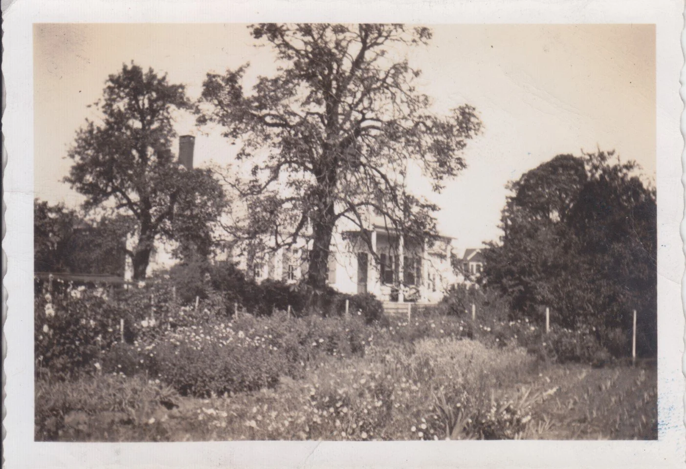
The Lott House and Farm Fields, 1922
Johannes H. Lott Expands the Farm

U.S. Census Bureau, Census 1850
When Hendrick I. died in 1840, he left his property to his only son, Johannes H. Lott. Johannes H., like his grandfather and great-grandfather, continued to purchase land in the Flatlands area. At the time of his inheritance, he owned approximately 242 acres. During the first half of the 19th century, the Lott’s farm saw success due to the population increase throughout the boroughs. According to the 1850 census, the farm was valued at $16,500 (estimated at around $595,000 in 2023), placing it thirteenth on the value list out of the 100 farms recorded in Flatlands. In the 1865 state census, the farm was the fourth largest in the county, estimated at a value of $22,000, out of the seventy recorded farms in Flatlands.
The First Half of the Nineteenth Century
Although grains continued to grow in Flatlands, a change was looming for the Lotts. With the opening of the Erie Canal and the development of the railroads in the 1850s, southern Kings County grain farmers now faced competition in the New York and Brooklyn markets from distant growers. Goods from New York and New Jersey were beginning to come into the market. To compensate, the Lotts, like many farmers in the area, began to switch their crops from grains to fruit and vegetables, mostly cabbages and potatoes. In 1875, the farm produced 33,000 heads of cabbage and 15,000 pounds of potatoes. The Lott family's livelihood depended on large-scale market farming, which would not have been possible without the help of hired labor. By the end of the nineteenth century, the Lotts were employing Irish, German, and Italian immigrant farm laborers to work the fields.

Immigrant girls harvesting cabbage at the Hendrick I. Lott House, 1880. Hendrick I. Lott House Collection.
Inlets, Creeks, and Marshes

Oyster Permit issued to Andrew H. Suydam by the Department of Health, New York City, 1908.
Along the coastline and the surrounding areas, marshes, creeks, and inlets offered an abundance of seafood for harvest and also afforded water transportation. Clams and oyster shells comprised the largest portion of sea life harvested. These were used for subsistence and held economic value. During the colonial period, oysters could grow up to a foot in size, and a single oyster could provide a meal for a family. By the end of the 19th century, oysters were being planted throughout Jamaica Bay and the Rockaways to offset the impact of harvesting.
John Bennett Lott and Andrew H. Suydam participated in oyster farming and were perhaps members of the Flatlands Oyster Planters Association. The industry in Flatlands employed over 300 men in Jamaica Bay alone.
In the early 20th century, the Great Migration saw thousands of black people move to the North from Southern states. Among them was a group of Black men from Gloucester, Virginia, who came to the Lott Farm. Though listed as farm laborers, they were also oystermen. By the mid-20th century, the once-thriving oyster industry declined due to over-harvesting and increasing sewage in the waterways. In 2016, the New York City Department of Environmental Protection announced an innovative project in partnership with the Billion Oyster Project to rehabilitate Jamaica Bay by installing 50,000 oysters. The Jamaica Bay Installation will help restore wildlife habitat, protect wetlands, filter pollutants, and prevent future erosion from storm surges.
The Underground Railroad


Flatlands. Kings Co. L.I., 1873
The Underground Railroad was a series of routes and safe houses that runaway slaves followed as they fled to areas with Free Black communities and Canada.
Oral history among the Lott family tells the story of a "closet within a closet" on the second floor of the Lott House. Inside one of the upstairs bedrooms is a newspaper pasted on the wall dated June 10, 1863. According to family tradition, within this closet, the Lott family hid freedom seekers who were participating as a stop on the Underground Railroad.
Located adjacent to Gerritsen's Creek, the Lott House was easily accessible to boats that may have come up the eastern shoreline. The property was also adjacent to Flatbush Road and the Kings Highway, which would have provided a relatively direct route to Weeksville, the free African American community located in present-day Crown Heights. Lastly, the Lott property was also extremely remote from Manhattan, friendly to bounty hunters seeking runaway slaves.
Today, New York State recognizes the Lott House as a stop on the Underground Railroad. It is also an example of changing political and cultural views between generations of the same family.
Downsizing the Farm
The Lott family underwent significant changes during the last quarter of the 19th century. Competition from distant farms and increased pressures of immigration and development in what would soon become the Great New York City and the development of the railway system led to a shift in food supplies that were no longer coming mainly from local farmers in New York City. This change affected the Lott family, and like most farmers in the area, they had to downsize and sell off pieces of their estate. Some plots of land were sold, while others were given away as dowry presents. These changes led to the reduction of the family's property. By the 1890s, the property was reduced to approximately 30 acres and would shrink to less than 10 acres by the turn of the twentieth century.
Despite these changes, the Lott family remained in the area and undertook formal landscaping of their property using monies they received from selling their land. They planted a formal garden and built a full-size tennis court.


Lott family photos from the mid-20th century featuring the full-size tennis court and garden facing East 35th Street. Hendrick I. Lott House Collection. Harvesting the Last Crop


Hendrick I. Lott House, 1927. Hendrick I. Lott House Collection.
John Bennett Lott's death in 1923 signaled the end of the family's farming pursuits. The grounds and house were passed to his wife, Phoebe. His brother George resided at the house, actively farming the property until the summer of 1925, the last season the Lotts harvested crops on the farm. Afterward, the family sold off most of the farm, and Mrs. Andrew Suydam inherited what was left.
By this time, the area had changed – from vast farmlands to small residential plots bound by railroad tracks. The city laid water lines throughout the former fields within a year of the last harvest. Instead of moving out to Long Island or New Jersey, Jennie and Andrew kept the family home with ¾ of an acre surrounding it. All that remained of the Lott property was a plot of 160 feet by 200 feet, roughly three-quarters of an acre, including the house.

Frederick, Edward B. "Old Lott Farm Is Doomed By Suburbia." New York Herald (New York), September 6, 1925.
Modernizing South Brooklyn

1924 aerial photo of the Marine Park neighborhood.
Modernization of Southern Brooklyn would not take place until the 1920s. Two factors allowed this area to retain remnants of its farm character. First, rail transportation rapidly grew throughout Manhattan and northwestern and southwestern Kings County. Many of the existing rail lines were built for access around Coney Island but did not extend into the southeastern sections of Kings County. The City sewer system did not extend into this area either. Sewers weren't placed in the area until the last half of the 1920s.
In 1927, the stone kitchen was razed as the City of New York formally laid sewer and water lines, asphalt streets, and concrete sidewalks along East 36th and East 35th Streets. The lands sold to real estate developers were now ready for resale and house construction.
Without the ability to transport the residents to the city for work or even meet the health and hygiene standards, this area of the County couldn't develop far beyond its rural nature.
Building Marine Park
The Lott family owned the majority of what would become the Marine Park neighborhood.

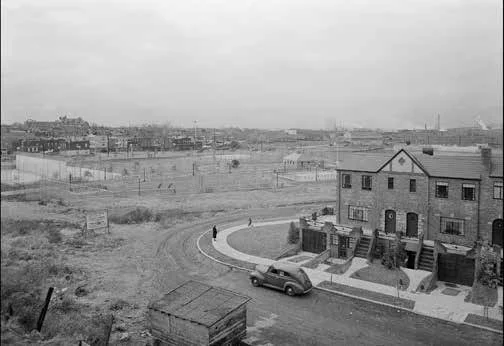
Brooklyn: Fillmore Avenue - 36th Street (East), 1931
Development of the area surrounding Gerritsen's Creek and the Lott House was spurred by plans for a new "marine" park west of Flatbush Avenue along Jamaica Bay until the late 1920s. The area was already known for its access to the water, hotels, and vacation homes in Coney Island, Manhattan Beach, and Rockaway, and housing developers were looking to expand housing further into Brooklyn.
Marine Park, general view, with sign "work now in progress", 1940
During the housing boom of the 1920s, developers took advantage of tax breaks to build affordable middle-class housing in the outer boroughs. "Marine Park" became the neighborhood's name, developing around the new park. Maps and photographs convey the dramatic transformation in less than a decade. Between 1920 and 1930, the new neighborhood saw a population increase of 1600%. By 1940, Marine Park was an established middle-class neighborhood. The heart of the neighborhood was the park and two commercial areas, Avenue S and Quentin Road.
Marine Park

Marine Park, Brooklyn, New York City: copied from drawing of Charles Downing Lay, landscape architect, 101 Park Ave., New York City, 1932
In the early 1930s, Charles D. Lay, a prominent New York landscape architect, proposed a grand public park for Gerritsen Inlet. The proposed park would have been among the largest in America if built. The January 1933 issue of Architectural Record listed many of its planned features: yacht basin, 500-foot wide canal, half-mile wide "big pond," menagerie, bowling greens, music grove, an open-air theater, and a stadium for 125,000 spectators, all served by a new subway line. The design won a silver medal in the 1936 Olympics. In 1935, Robert Moses scrapped Lay's plan, and a new scaled-down project was commissioned from the firm of Clarke and Rapuano.
The Last of the Lotts


By 1952, Jennie and Andrew Suydam lived at the house with their two daughters, Anna and Ella, who inherited the house after their deaths. Jennie and Andrew remained at the house for the remainder of their lives. Andrew established extensive flower gardens. Ella continued to live with her parents. Anna eventually joined her when she became a widow. The two often hosted Anna's grandchildren on visits. Ella never married and spent her career as the head librarian at Erasmus Hall High School. She would be the last direct descendant of Colonel Johannes H. Lott to live in the house. She died at the Lott Homestead in July 1989.
Landmarking the Lott House
In 1966, the New York City Landmarks Preservation Commission, at the request of several residents, investigated the possibility of making the Lott House a New York City landmark. However, Ella Lott Suydam was against the landmarking of her family home. She argued that as a private landowner, the city had no right to designate her family's house and grounds.
Nine years later, again at the request of community residents, the Landmarks Commission re-opened the Lott House case. Ella Lott Suydam's health was rapidly declining. If the house was not landmarked, it could be torn down, and row houses could be constructed. Once again, Ella refused to allow for landmark status. Ella's relatives, who would stand to inherit the house at her death, also argued against landmark status, saying that it infringed on their rights as private property owners to be forced into accepting this designation.

“Who the hell are you to tell me I can do with my house?” the owner, Ella Suydam, told the board on Thursday. It was considering a recommendation from the Landmarks Preservation Commission that it ratify designation for her house and the three-quarter-acre lot at 1940 36th street in the Marine Park section of Brooklyn.”
In July 1989, Ella Suydam passed away. Fearing the loss of yet another remnant of "old" Brooklyn, the Landmarks Preservation Commission granted landmark status without Ella's permission. In October 1989, the Hendrick I. Lott House and grounds were granted New York City Landmark status. Soon after, State and National Register landmark status were granted.


Hendrick I. Lott House, 1997. Hendrick I. Lott House Collection.
Archeology at the Farm House
In the late 1990s, the Brooklyn College Summer Archaeological Field School began a long-term archaeological project at the Lott House. The excavation provided a closer look into the uninterrupted history of over 250 years of one Dutch family. Over several years, the Field School discovered over 65,000 artifacts and former structures representing the Lott family, enslaved persons and their descendants, and immigrant workers at the Lott House.
The Stone Kitchen


Brooklyn College Summer Archaeological Field School excavating the Stone Kitchen, 1999. Hendrick I. Lott House Collection. Photos of the Stone Kitchen, early 20th century. Collection of Hendrick I. Lott House. One of the structures uncovered was the foundation for the old stone kitchen. Demolished in 1927, the outdoor kitchen was used for outdoor and summer cooking and was separate from the main wooden house. Interestingly, the stone kitchen wasn't actually made of stone. It did have a stone foundation, but the building was made of brick. The foundation of the building is still underground.
The Privy


Brooklyn College Summer Archaeological Field School excavating the Stone Kitchen, 1999. The Field School also unearthed a privy dating from the late 19th century near the Lott House. A privy was the common name for an outhouse or outdoor toilet, which was commonly used before indoor plumbing became available. The Lott House privy revealed a look into everyday life on the farm in south Brooklyn. Objects unearthed included several chamber pots, medical bottles, porcelain doll parts, and several opium bottles.
The Attic


A small trap door was discovered in the ceiling of the kitchen closet, which is the oldest portion of the house, dating to 1720. Once opened, the trap door led to an old stairway with only three steps remaining. The stairs led to a forgotten doorframe that once opened to a second-floor room of the house. When removing the floorboards in the space, the archaeologists discovered corncobs in the corner of the room between the chimney and the door. It appears they were deliberately laid in the shape of an "X" or a cross. These cobs still had their kernels, meaning they had not been eaten or stripped but dried whole. Their deliberate placement suggested a ritual association. An "X" is a commonly seen symbol on objects used for ritual purposes by the enslaved. It is West African in origin and known as the Bokongo cosmogram, representing the boundary between the world of the living and the world of the deceased.

The Hendrick I. Lott House is a rare survivor of Brooklyn’s agrarian past.
Occupied for nearly 300 years by a single family, the Lott House is a physical embodiment of every important era in the history of the United States, New York City, and Brooklyn. It has been home to scores of women and men, immigrant and native-born, enslaved and free, who helped transform a wild land into New York City. In 2001, the City of New York purchased the Lott House, and it became part of the Historic House Trust of New York. In 2008, the New York City Department of Parks & Recreation completed an extensive exterior restoration and a landscape renovation in 2013.
Today, the house is managed by Friends of the Lott House, who are dedicated to the house’s preservation and interpretation. To learn more about the upcoming renovation and restoration project, click here.
Bibliography
Bankoff, H. Arthur, Alyssa Loorya, and Christopher Ricciardi. "Remembering Africa Under the Eaves." Archeology Magazine https://archive.archaeology.org/0105/abstracts/lott.html.
Baxter, John. 1835. Diary 1790 to 1835. Brooklyn Historical Society; Brooklyn, New York.
Black, Frederick R. Historic Resource Study: Jamaica Bay: A History: Gateway National Recreation Area, New York - New Jersey. National Park Service, Washington, DC.
Bolton, Reginald Pelham. 1922. Indian Paths In The Great Metropolis. Indian Notes And Monographs. Museum of The American Indian, New York, New York.
Burrows, Edwin G., and Mike Wallace. 1999. Gotham: A History Of New York City To 1898. Oxford University Press, New York, New York.
Cohen, David Stephen. 1992. The Dutch-American Farm. New York University Press, New York, New York.
DeRosa, Sister Mary Luliana. "Colonial Dutch Life In Flatbush As Portrayed By The Lott Family." Thesis, St. Francis College, Brooklyn, New York, 1961.
Campanella, Thomas J. Brooklyn: The Once and Future City. Princeton University Press, 2019.
Campanella, Thomas J. “Playground of the Century: A Political and Design History of New York City’s Greatest Unbuilt Park.” Journal of the Society of Architectural Historians 72, no. 2 (2013): 189–204. https://doi.org/10.1525/jsah.2013.72.2.189.
Edwards, Frederick B. September 6, 1925. “Old Lott Farm Is Doomed by Suburbia.” New York Herald Tribune.
Irma and Paul Milstein Division of United States History, Local History and Genealogy, The New York Public Library. "Brooklyn: Fillmore Avenue - 36th Street (East)" New York Public Library Digital Collections. https://digitalcollections.nypl.org/items/510d47dc-cda8-a3d9-e040-e00a18064a99
Koeppel, Gerard T. Water for Gotham: A History. Princeton University Press, 2000. http://www.jstor.org/stable/j.ctv1vwbtt9.
Lidner, Marc and Lawrenence S. Zacharias. 1999 Of Cabbages And Kings County: Agriculture And The Formation Of Modern Brooklyn. The University of Iowa Press, Iowa City, Iowa.
Lionel Pincus and Princess Firyal Map Division, The New York Public Library. "Flatlands. Kings Co. L.I." New York Public Library Digital Collections. https://digitalcollections.nypl.org/items/510d47e2-6349-a3d9-e040-e00a18064a99
Loorya, Alyssa. Why Have All the Farms Disappeared? Rural to Urban Transformation in Flatlands, Long Island 1875-1930 and its Cultural Impact as evidenced at the Hendrick I. Lott Homestead. Department of Anthropology, City University of New York’s Graduate Center, New York, New York.
Marine Park, Brooklyn, New York City: copied from drawing of Charles Downing Lay, landscape architect, 101 Park Ave., New York City; [1932], Map Collection, B A-[1932?]. Fl.Folio; Brooklyn Historical Society.
New York (City) Landmarks Preservation Commission .1989.Lott House Designation Report New York City Landmarks Preservation Commission, New York, New York.
New York State Archives. New York (State). State Engineer and Surveyor. Survey maps of lands in New York State, ca. 1711-1913. Series A0273-78, Map #368. 2 Maps of the Town of Flatbush, Kings County. Per Jeremiah Lott. Dated 10th of November, 1797 and 20th of November, 1797.
New York State Archives. New Netherland. Council. Dutch colonial patents and deeds, 1630-1664. Series A1880. Volume GG. Patent. Andries Hudde and Wolphert Gerritsen (van Couwenhoven); westernmost of the flatts on Long Island, between the bay of the North river and the East river; ratified 22 August, 1658.
Phillips, A. Van Cleve. 1942 The Lott Family In America. Edwards Brothers, Inc., Ann Arbor, Michigan.
Ricciardi, Christopher. 2004. Changing through the Century: Life at the Lott family farm in the Nineteenth Century Town of Flatlands, Kings County, New York. Dissertation, Syracuse University.
Thomas, Robert McG."Protectionists Beats Preservationists." New York Times (New York City), September 20, 1980.
Steinberg, T. 2014. Gotham Unbound: The Ecological History of Greater New York. Simon and Schuster. New York.